Intelligent LiDAR mapping and a navigating system for drones – Hovermap
SIEF supports intelligent LiDAR mapping and a navigating system for drones (Hovermap)
The challenge
Every year, Australia loses billions of dollars due to infrastructure failures, spends billions of dollars on inspecting its aging assets and loses some of its bravest men and women who take the risk to do this dangerous job. Utility companies and governments are turning to Unmanned Aerial Vehicles (UAVs) to reduce costs and improve safety.
While there is a hungry global market for UAVs/ drone technology, the drones we currently have are ‘dumb and blind’. Drones rely on GPS navigation and so cannot sense the world around them and react accordingly; therefore they cannot be flown autonomously indoors, underground, or close to large structures that interfere with GPS.
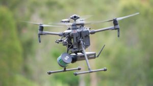
A drone in flight carrying the Hovermap UAV LiDAR payload (Image: CSIRO)
The response
Hovermap is a self-contained software and hardware system (payload) developed by CSIRO’s Data61 that attaches to existing drones to provide omni-directional 3D sensing for collision avoidance and accurate LiDAR (light imaging, detection, and ranging) mapping. The tool has capability to safely and efficiently inspect hard-to-reach assets and collect extremely high-fidelity data in previously unreachable places.
Function: As the Hovermap LiDAR rotates it produces a full spherical field of view around the drone for mapping and collision avoidance within range of 100 m. This makes it possible to map above, below and all around simultaneously enabling Hovermap to map indoors, underground and underneath overhanging structures such as bridges.
Map Generation: LiDAR data is logged on-board and processed on a laptop after the flight to produce accurate 3D point clouds.
The technology provides the following key benefits:
- No GPS is required for mapping and enabling drones to be flown indoors and underground compared to conventional solutions.
- Fast processing (2:1 process-to-capture time)
- Spherical Field of View – map below, above and all around
- Suitable for night-time or low-light mapping
- Individual maps can be automatically fused to generate a larger map, or fused with handheld-generated maps to combine aerial and terrestrial-based maps.
- Automatic change detection in consecutive maps
The SIEF Experimental Development Program (EDP) supported the Hovermap team to flight test the technology in real-life situations and translate current prototypes into commercial products.
The collaboration
Emesent is a drone autonomy and data analytics spin-out from CSIRO’s Data61 that is commercialising the revolutionising award-winning drone autonomy technology. After raising $4.5 million in venture capital to commercialise its first product, Hovermap, Emesent was launched in November 2018.
Outputs
- Development of Hovermap with four autonomy capabilities namely collision avoidance, GPS-denied flight application –specific autonomy for the inspection of telecom towers and mapping of underground mines.
- Early adopter program for Hovermap to develop a prototype version that could be utilised for commercial application in a variety of applications and for the continuous improvement of the tool.
- Development of technology enabled capability of drones to fly autonomously even in GPS-denied environments to collect insightful data safely, timely and cost-effectively; these capabilities were previously not possible.
- CSIRO’s Data61 branch, working with Emesent, was selected as one of seven finalists to win funding in the US Defense Advanced Projects Agency (DARPA) Subterranean Challenge project with a $2M USD (€1.7M EUR) prize; CSIRO was the only non-American participant.
- Hovermap won the Industrial & Primary Industries iAward at the iAwards Queensland 2018, Australia’s longest running and most broadly scoped innovation recognition program, promoting excellence in the Australian digital ecosystem from the likes of Google Maps, Atlassian, Wotif and WiseTech Global
Evidence of outcomes and impacts
Outcomes
With multiple applications across several industries, Hovermap and other solutions offered by Emesent are being used commercially for a variety of applications by customers in Australia, US, Canada, China and Japan. Some of the preliminary applications of the Hovermap enabled drones, have been to accomplish the following:
- Asset management (Construction/ telecommunication (inspection and mapping of towers)/ process plant assets/ mines)
- Infrastructure and building inspection
- Forensic crime scene mapping
- Underground mine mapping
- Construction site mapping
- Power line mapping
- Collecting 3D data and images for industrial inspections
Examples of how the technology is being used to address the above applications can be found at the bottom of the page.
Impacts
- Improving data collection service quality, accuracy and efficiency while reducing the costs and risks of sending people into difficult terrain to inspect assets and map landscapes.
- Reducing the costs incurred by Australian companies, the community, and the government in maintaining critical facilities and infrastructure, such as power, communications, transport, water, and oil and gas. For example, more regular and easier power line inspections by drones using Hovermap technology could help prevent bushfires caused by faulty lines.
- Avoiding the damage, loss, and injuries which can occur when drones (which lack Hovermap technology) collide.
- Driving commercial growth in the international drone market, generating investment in Australian R&D and enabling new drone applications to be developed, in turn creating job growth and increased business opportunities.
- Ability to rapidly explore and map challenging underground environments, to provide unprecedented situational awareness in time-critical scenarios such as disaster response, advanced communication systems for harsh indoor environments, thereby safeguarding the nation.
- Helping Australia realise its global digital innovation potential while benefitting Australian companies (mentioned above), communities and Government through maintaining critical facilities and infrastructure.
Technologies receiving ongoing commercialisation support from venture capital or industry sources
- Establishment of Emesent in November 2018, a drone autonomy and data analytics spin-out from CSIRO’s Data61 that raised $4.5 million in venture capital to commercialise its first product, Hovermap.
- Finalisation of the design of the prototype Hovermap payload and building of the eight units for Early Adopter Program.
- Design of a commercial-ready version of Hovermap and improved usability of the system through the development of better interfaces.
Examples where Hovermap has been used
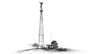
This communications tower and support buildings were mapped with the Hovermap UAV LiDAR payload in a few minutes. Three vertical transects were performed at a distance of 4-6m from the tower (Source: CSIRO).
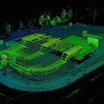
This construction site has been mapped a number of times with the Hovermap UAV LiDAR payload. The successive scans are automatically aligned allowing accurate monitoring of changes over time. The entire 100 x 70m site is mapped in a single 10min flight by flying 4 GPS transects approximately 12m apart. For the first three scans the flight altitude was 10m above the terrain and for the 4th scan the altitude was adjusted to remain at least 4m clear from the building roof. (Source: CSIRO)
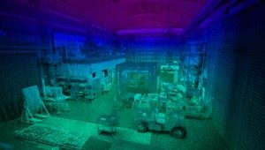
This industrial shed was mapped by flying the Hovermap UAV LiDAR payload indoors for a few minutes (Source: CSIRO)
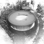
These liquid storage tanks were mapped using the Hovermap UAV LiDAR payload, each within a few minutes. (Source: CSIRO)
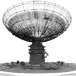
The Parkes Radio Telescope was mapped with the Hovermap UAV LiDAR payload by flying around it four times at different heights, in a total of 15 mins. Due to safety reasons, it wasn’t possible to fly directly over the dish therefore, the receiver and supporting structure were mapped sparsely. The supporting structure of the dish was mapped from underneath, demonstrating the spherical field-of-view of the HoverMap payload. (Source: CSIRO)
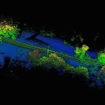
Two sections of power distribution lines have been mapped with the Hovermap UAV LiDAR payload. These scans can be used to measure the distance between the power lines and the surrounding vegetation. The scans were obtained by flying within 5-8 m of the power lines. Since Hovermap has a spherical field of view some of the lines could be mapped by flying underneath them. (Source: CSIRO)
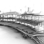
The Sydney Cricket Ground was mapped with the Hovermap UAV LiDAR payload by flying around the inside of the stadium once at around 5m above the lower seating area and a further two flights for the historic Members’ and Ladies’ Pavilions. For these pavilions, three passes at different heights were performed, up to roof level. A slightly higher flight for the grandstand to the left of the Ladies Pavilion was also conducted. For safety reasons, it wasn’t possible to fly higher and map the upper portions of the grandstands. The results from all the flights have been combined in the images. The total flight time was approximately 40 mins. (Source: CSIRO)